Carrying out studies for the development of wind energy projects and wind maps, through observation and simulation techniques
Studies for development of eolian projects and wind power maps in order to calculate the wind potential of an area and determine whether it is suitable for the installation of a wind farm.
These simulation and observation techniques are related to the analysis and simulation of severe weather episodes (storms, tornadoes, swirls, hail, floods, hurricanes, etc.) using atmospheric models and numerical techniques from the synoptic scale to the mesoscale, with special attention to the phenomena of high social impact. The synoptic scale is a scale of horizontal length of 1,000 km or more. It is typical of depressions, storms, troughs, ridges anticyclones, etc. and last between one day and one month. On the other hand, mesoscale consists of atmospheric weather phenomena smaller than the synoptic scale but larger than the micro-scale. It is therefore related with phenomena that last between 1 and 12 hours; or with a horizontal extension of between 1 and 100 km; or a height of between 1 and 10 km: convective storms, tornados, sea breezes, etc.
The profitability of wind farms at a location depends heavily on the wind potential at that site. This potential is determined by the climatic characteristics of the area, such as the average wind and its variability. The studies consist of continuous measurements of wind speed and direction and also the use of numerical atmospheric models to calculate the wind potential of an area and determine whether it is suitable for the installation of a wind farm.
OUR EXPERIENCE
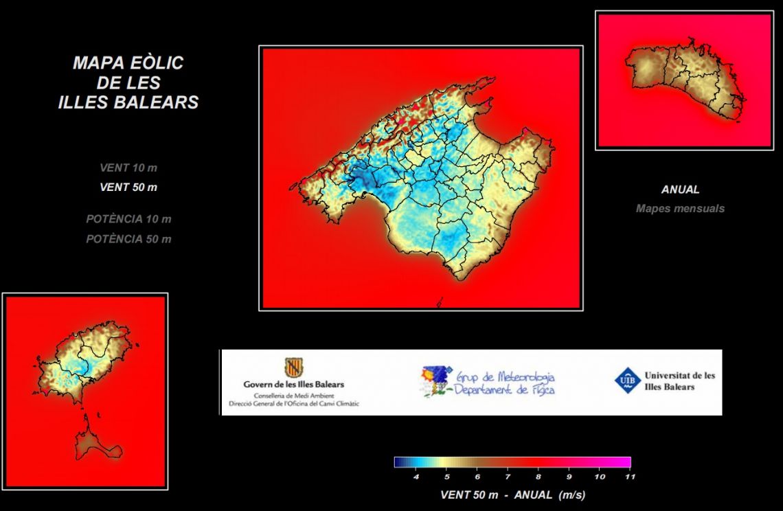
Development of a wind potential map of the Balearic Islands
This study presents a wind map of the Balearic Islands as a basis for future climatological and energy applications. The creation of the wind map has been based on the realization of meteorological simulations at a very high resolution (grid length of 200 m) over a period of four years (September 2004-September 2008) using the CALMET diagnostic model. The diagnostic model aims to achieve the dynamic adjustment of a large-scale initial wind, to the finer aspects of the insular topography, such as steep, sloping valleys, slopes, mountains and coastal areas.